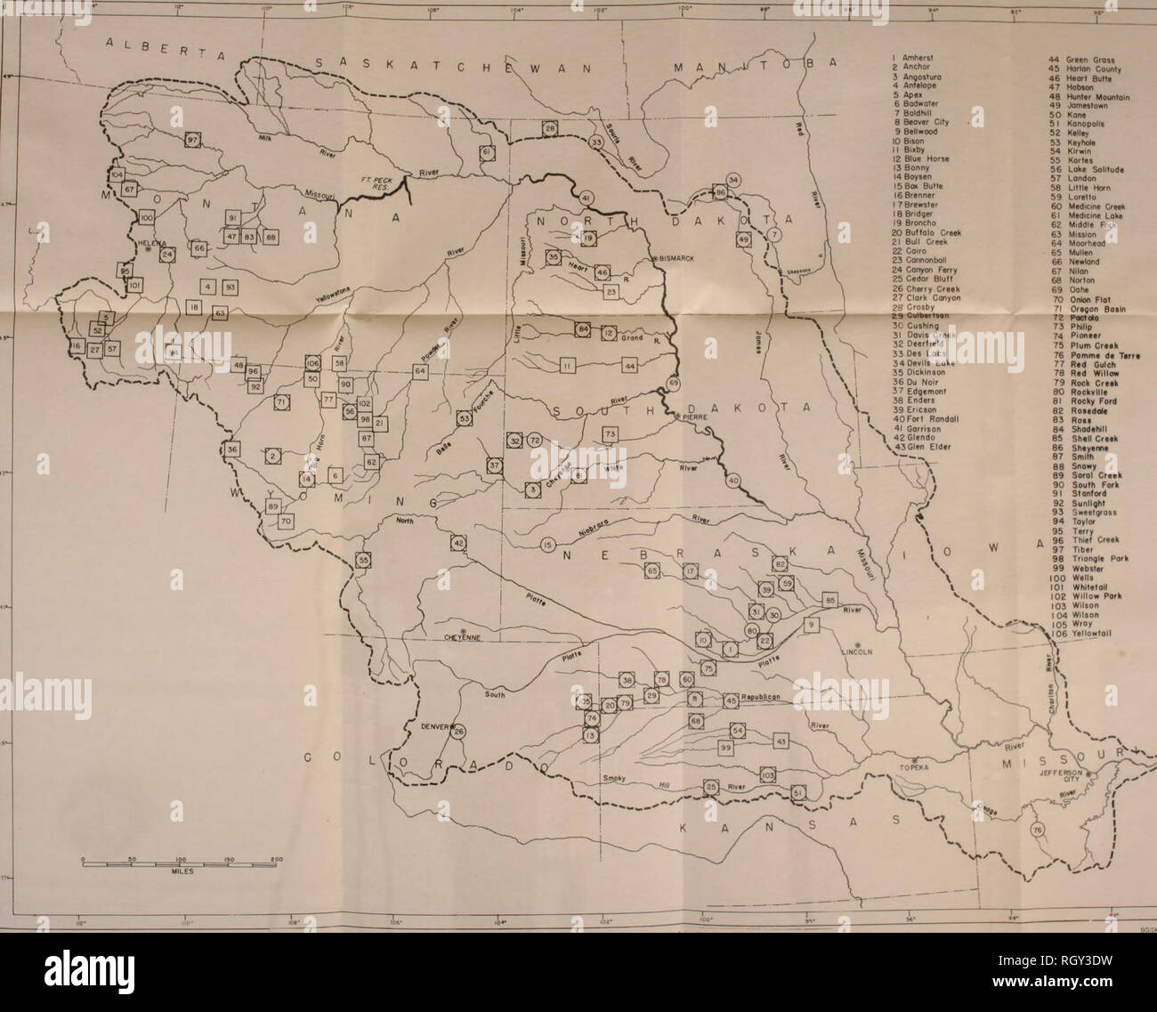
. Bulletin. Ethnology. 1 Amherst 2 Anchor 3 Angosluro 4 AnTalope 5 Ape> 6 Bodwoter 7 Boldhill 8 Beover City 9 Belloood 10 Bii 11 Bmby 12 Blue Horse 13 Bonny 14 Boysen ISBoK Butte 16 Brenner I 7 Brewster 18 Bndger 19 Broncho 20 Buffolo Creek 21 Bull Creek 22 Coiro 23 Connonboll 24 Conyon Ferry 25 Cedor Bluff 26 Cherry Creek 27 Clork Conyon 28 Crosby 23 Culb«rte«n 3C CusMng 31 Oovls Creek 32 Deerfleld 33 Oe> Lacs 34 0evlli Lake 35 Dickinson 36 Du Noir 37 Edgemont 38 Enders 39 Ericson 40 Fort Rondoll 41 Garrison 42Glendo N 43 Glen Elder. 44 Green Gross 4b Horlon County 46 â leort Butte 47
Image details
Contributor:
Library Book Collection / Alamy Stock PhotoImage ID:
RGY3DWFile size:
7.1 MB (292.1 KB Compressed download)Releases:
Model - no | Property - noDo I need a release?Dimensions:
1761 x 1419 px | 29.8 x 24 cm | 11.7 x 9.5 inches | 150dpiMore information:
This image is a public domain image, which means either that copyright has expired in the image or the copyright holder has waived their copyright. Alamy charges you a fee for access to the high resolution copy of the image.
This image could have imperfections as it’s either historical or reportage.
. Bulletin. Ethnology. 1 Amherst 2 Anchor 3 Angosluro 4 AnTalope 5 Ape> 6 Bodwoter 7 Boldhill 8 Beover City 9 Belloood 10 Bii 11 Bmby 12 Blue Horse 13 Bonny 14 Boysen ISBoK Butte 16 Brenner I 7 Brewster 18 Bndger 19 Broncho 20 Buffolo Creek 21 Bull Creek 22 Coiro 23 Connonboll 24 Conyon Ferry 25 Cedor Bluff 26 Cherry Creek 27 Clork Conyon 28 Crosby 23 Culb«rte«n 3C CusMng 31 Oovls Creek 32 Deerfleld 33 Oe> Lacs 34 0evlli Lake 35 Dickinson 36 Du Noir 37 Edgemont 38 Enders 39 Ericson 40 Fort Rondoll 41 Garrison 42Glendo N 43 Glen Elder. 44 Green Gross 4b Horlon County 46 â leort Butte 47 Hobson 48 Hunter Mounloin 49 Jomestown 50 Kone 51 Kanopolis 52 Kelley 53 Keyhole 54 KIrwin 55 Kortes 56 Loke Solitude 57 London 58 Ultle Horn 59 Loretto 60 Medicine Creek 61 Medicme Loke 62 Middle Fork 63 Mission 64 Moorheod 65 Mullen 66 Newland 67 Nilan 6fl Norton 69 Oohe 70 Onton Flat 71 Oregon Basin ri Poctslo n Philip 74 Pioneer 75 Plum Creek 76 Pomme de Terr* 77 Red Gulch 78 Red WilloK 79 Rock Creek 80 Rockvllle 81 Rocky Ford 82 Rosedole 83 Ross 84 Shodehill 85 Shell Creek 86 Sheyeme ar Sinlth 88 Snowy 89 Soral Creek 90 South Fork 91 Stanford 92 Sunlight 93 Sweetgross 94 Taylor 95 Terry 9R Thief Creek 97 Tiber 98 Tnongle Pork 99 Webster IOC Wells 101 Whitetoll 10? Willow Pork 103 Wilson 10' Wilson lOfi Wroy »'a»> â¢""''''" "">â »â showiilK reseivoii projects inveslii-'utwl by tlie Missouri Wver Basin Survey and looiierallnd agencies as of December 31. I!t48. Numbers designatlne proJe<ts corresponil to those in colHiuu 1 of table 1. Circles indicate archeoloRical Inyestittatloii; boxes indicate paleontolosical exainini.li.ui: t"'»«<J Hrdes indicate ar.heol- ogical and paleontological investigations.. Please note that these images are extracted from scanned page images that may have been digitally enhanced for readability - coloration and appearance of these illustrations may not perfectly resemble the origin