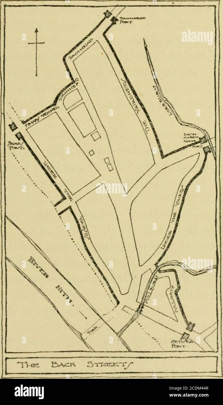
. Transactions and journal of proceedings . Topography of Dumfries. 185 indicate the iiuiir to which the wretched plag^uc-strickcnpeople were expelled. On the Lockerbie Road is the BaneLoaning, and near by, beside the Black Loch, are the Dead-mans Hirst and the Scabbit Isle—ominous relics of ;in eilthat even the burghs patron saint, the archangel Michael,failed to overthrow. Closes: Back Streets. None the less the burgh would grow. The houses in theHigh Street would increase in number and begin to spreadalong the main exits. Each dwelling in the mediaeval burghordinarily had its yard behind o
Image details
Contributor:
Reading Room 2020 / Alamy Stock PhotoImage ID:
2CDM44RFile size:
7.1 MB (231.1 KB Compressed download)Releases:
Model - no | Property - noDo I need a release?Dimensions:
1215 x 2056 px | 20.6 x 34.8 cm | 8.1 x 13.7 inches | 150dpiMore information:
This image is a public domain image, which means either that copyright has expired in the image or the copyright holder has waived their copyright. Alamy charges you a fee for access to the high resolution copy of the image.
This image could have imperfections as it’s either historical or reportage.
. Transactions and journal of proceedings . Topography of Dumfries. 185 indicate the iiuiir to which the wretched plag^uc-strickcnpeople were expelled. On the Lockerbie Road is the BaneLoaning, and near by, beside the Black Loch, are the Dead-mans Hirst and the Scabbit Isle—ominous relics of ;in eilthat even the burghs patron saint, the archangel Michael, failed to overthrow. Closes: Back Streets. None the less the burgh would grow. The houses in theHigh Street would increase in number and begin to spreadalong the main exits. Each dwelling in the mediaeval burghordinarily had its yard behind or beside it. As each burgessgrew at least a part of his own food, he had on this groundhis barnyard, barn, kiln, and coble or stone trough—used for. 186 Topography of Dumfries. threshing, drying, and steeping the grain. We can stilltrace the lines of these houses and the depth of the yards.The houses lay along the west side of the High Street and St.Michael Street, the east side of Queensberry Street, and thesouth side of English Street. The yards extended respectivelyto Irish Street, the river, Loreburn Street, and ShakespeareStreet. Access to the barns and yards was obtained natur-ally by passages at the sides of the houses (for between eachrig was a waste piece of ground) and at the ends of the yards.In these side passages we have the origin of our closes, ^^ andin the passages at the ends the beginning of such streets, still unable to throw off their original characters, as LoreburnStreet, Shakespeare Street, and Irish Street. In the i6thcentury Loreburn Street was the passage at the * yaird-heidis, Shakespeare Street and Irish Street were passages under the yairds, and in the i8th century they were all the Barnraws. All these s