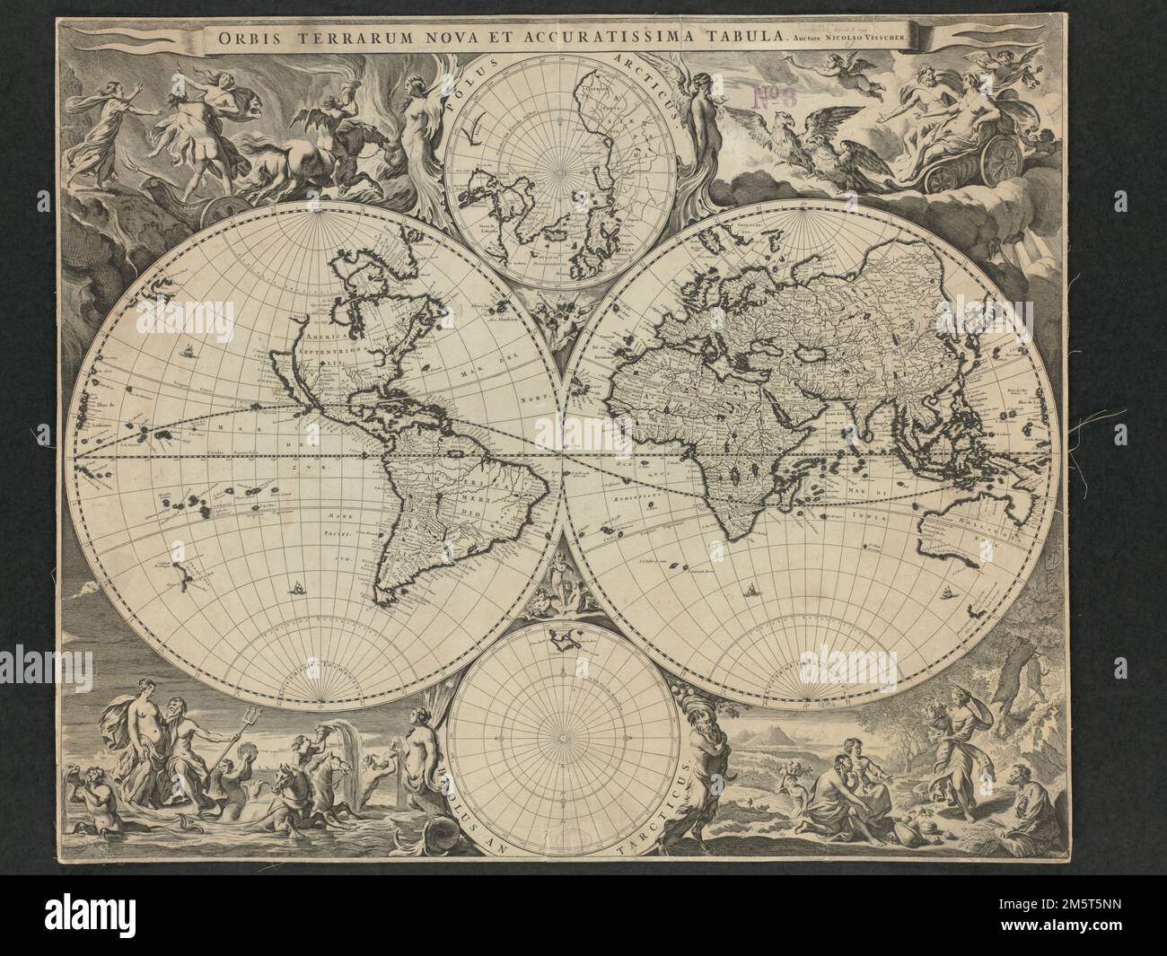
Orbis terrarum nova et accuratissima tabula. Relief shown pictorially. Includes ancillary maps of north polar region and south polar region and col. ill. Exhibited in “Journeys of the Imagination,” at the Boston Public Library, Boston, MA, April - August 2006. MB (BRL). As a variation to earlier double hemisphere world maps, Visscher, a mid-17th-century Dutch cartographer, added two smaller spheres to his presentation, with each depicting the northern and southern polar regions. His map, also ornately decorated, first appeared in Jan Jansson's 1658 ''Novus Atlas''. The map was reused, unchange
Image details
Contributor:
LM/BT / Alamy Stock PhotoImage ID:
2M5T5NNFile size:
254 MB (11.8 MB Compressed download)Releases:
Model - no | Property - noDo I need a release?Dimensions:
10880 x 8160 px | 92.1 x 69.1 cm | 36.3 x 27.2 inches | 300dpiMore information:
This image is a public domain image, which means either that copyright has expired in the image or the copyright holder has waived their copyright. Alamy charges you a fee for access to the high resolution copy of the image.
This image could have imperfections as it’s either historical or reportage.
Orbis terrarum nova et accuratissima tabula. Relief shown pictorially. Includes ancillary maps of north polar region and south polar region and col. ill. Exhibited in “Journeys of the Imagination, ” at the Boston Public Library, Boston, MA, April - August 2006. MB (BRL). As a variation to earlier double hemisphere world maps, Visscher, a mid-17th-century Dutch cartographer, added two smaller spheres to his presentation, with each depicting the northern and southern polar regions. His map, also ornately decorated, first appeared in Jan Jansson's 1658 ''Novus Atlas''. The map was reused, unchanged, in later atlases compiled by the Visscher family and in composite atlases. Visscher's world map influenced other late 17th-century Dutch cartographers in the production of highly decorative world maps. The map's uniqueness and distinct attraction is its marginal decorations which were the work of artist Nicolaes Berchem. The artist created four dramatic scenes from classical mythology--the rape of Persephone amidst a flaming background, Zeus as he was carried across the heavens in an eagle-drawn chariot, Poseidon and his entourage emerging from the sea, and Demeter receiving the fruits of the land. These vignettes are also suggestive of the four basic elements. Geographically, the information presented on this map did not differ significantly from earlier Dutch maps. It continued the practice of showing California as an island, an interpretation that first appeared on English maps in the mid-1620s, and was quickly adopted by Dutch cartographers in the 1630s... , World