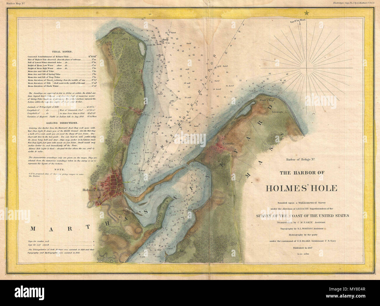
. Harbor of Refuge No. The Harbor of Holmes' Hole. English: This is a rare example of the 1847 U.S. Coast Survey nautical chart or map of Holmes’ Hole (Vineyard Haven), Martha’s Vineyard, Massachusetts. Focusing on the town of Holmes’ Hole, today’s Vineyard Haven, this map covers from West Chop to East Chop and as far south as Little Neck and Lagoon Pond. Presents a rare mid-19th century view of one of Martha’s Vineyard’s three main population centers. This map offers exceptional inland detail noting individual streets, farms and buildings in Holmes’ Hole and Eastville. Countless depth soundi
Image details
Contributor:
The Picture Art Collection / Alamy Stock PhotoImage ID:
MY8E4RFile size:
14.3 MB (1.3 MB Compressed download)Releases:
Model - no | Property - noDo I need a release?Dimensions:
2606 x 1918 px | 22.1 x 16.2 cm | 8.7 x 6.4 inches | 300dpiMore information:
This image is a public domain image, which means either that copyright has expired in the image or the copyright holder has waived their copyright. Alamy charges you a fee for access to the high resolution copy of the image.
This image could have imperfections as it’s either historical or reportage.
. Harbor of Refuge No. The Harbor of Holmes' Hole. English: This is a rare example of the 1847 U.S. Coast Survey nautical chart or map of Holmes’ Hole (Vineyard Haven), Martha’s Vineyard, Massachusetts. Focusing on the town of Holmes’ Hole, today’s Vineyard Haven, this map covers from West Chop to East Chop and as far south as Little Neck and Lagoon Pond. Presents a rare mid-19th century view of one of Martha’s Vineyard’s three main population centers. This map offers exceptional inland detail noting individual streets, farms and buildings in Holmes’ Hole and Eastville. Countless depth sounding throughout. The upper left quadrant features notes on tides and detailed sailing instructions. The triangulation for this chart was completed by C. M. Eakin. The stunning topographical detail is the work of H. I. Witing. The hydrography was completed by a party under the command of G. S. Blake. The entire chart was produced under the supervision of A. D. Bache, of the most prolific and influential Superintendents of the U.S. Coast Survey. The map was not originally colored. Coloring maps is a common practice today to make the map more visually interesting but it is not authentic or attributed to the original map maker. An example of the original appearance of this map can be found here http://www.raremaps.com/gallery/detail/25393/The Harbor of Holmes Hole 1847/United%%%%20States%%%%20Coast%%%%20Survey.html . 1847 (dated) 6 1847 U.S. Coast Survey Map of Holmes' Hole (Vineyard Haven), Martha's Vineyard, Massachusetts - Geographicus - HolmesHole-uscs-1847