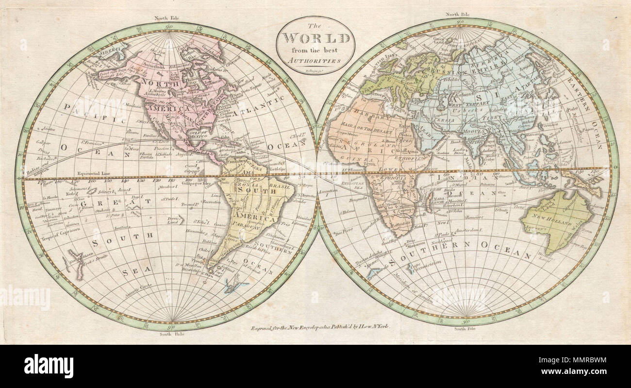
. English: An extremely rare and unusual map of the world. Printed in 1798, this is one of the first maps of the world published for general audiences in the New World. While lacking in the refinement commonly seen in European maps of the same period, this map is worthy of special note by collectors as a fine example of early American cartography. Map depicts the entire world on a hemisphere projection. Geographically offers a few curious anomalies and curiosities. Alaska is expressed in its general form if bloated and inflated in the Aleutian region. Depicts several oddities in the South Pac
Image details
Contributor:
The Picture Art Collection / Alamy Stock PhotoImage ID:
MMRBWMFile size:
14.3 MB (1 MB Compressed download)Releases:
Model - no | Property - noDo I need a release?Dimensions:
3026 x 1652 px | 25.6 x 14 cm | 10.1 x 5.5 inches | 300dpiMore information:
This image is a public domain image, which means either that copyright has expired in the image or the copyright holder has waived their copyright. Alamy charges you a fee for access to the high resolution copy of the image.
This image could have imperfections as it’s either historical or reportage.
. English: An extremely rare and unusual map of the world. Printed in 1798, this is one of the first maps of the world published for general audiences in the New World. While lacking in the refinement commonly seen in European maps of the same period, this map is worthy of special note by collectors as a fine example of early American cartography. Map depicts the entire world on a hemisphere projection. Geographically offers a few curious anomalies and curiosities. Alaska is expressed in its general form if bloated and inflated in the Aleutian region. Depicts several oddities in the South Pacific including “Davis’s Land and “Land Seen by Quiros”. “Davis’s Land” appeared on a few charts in the later part of the 19th century and was supposedly discovered by Captain Davis 1722. It was claimed that “Davis’s Land” was a large body of land south and slightly to the east of the Galapagos Islands. Some suppose it to have been Easter Island, while others simply suggest that it was a complete fabrication. Antarctica is shown sketchily as Terra Australis, Cape Circumcision, and the Gulf of Sebastian. In Australia, or New Holland as it is labeled, Tasmania (Van Diemen’s Land) is attached to the Australian mainland. In east Asia, map depicts the Sea of Korea, Yeso Island, and mysterious Company’s Land. Prepared by Rollinson for John Payne’s New Universal Geography and I. Low’s New Encyclopedia . The World from the best authorities.. 1798 (undated). 1798 Payne Map of the World (pre 1800 American Map) - Geographicus - World-payne-1798