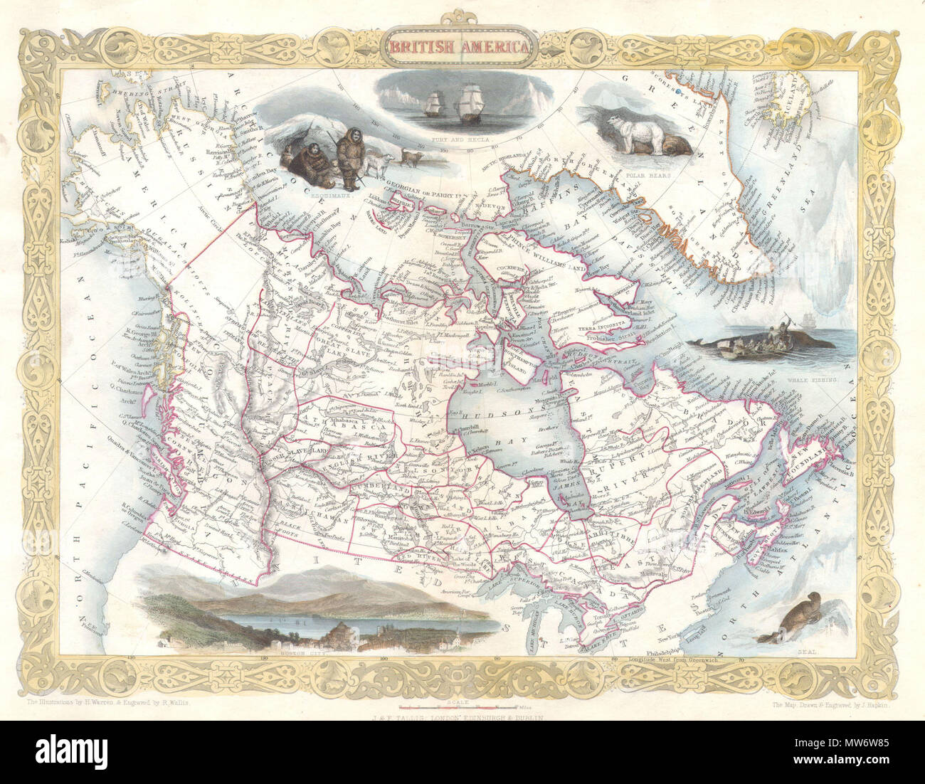
. British America. English: This is a rare and curious first state first edition of Tallis’s 1849 map of British America or what is today Canada. Extends from Russian America ( Alaska ) east as far as Greenland and Iceland. Inexplicably, this map recognizes the British claim to Oregon as far south as the Columbia River. This dispute was supposedly resolved three years previously in 1846 by the “Oregon Treaty” which officially set the U.S – British America border at the 49th parallel. Features numerous decorative vignettes typical of Rapkin / Tallis work including a seal, whale fishing, the ex
Image details
Contributor:
The Picture Art Collection / Alamy Stock PhotoImage ID:
MW6W85File size:
14.3 MB (1.1 MB Compressed download)Releases:
Model - no | Property - noDo I need a release?Dimensions:
2533 x 1973 px | 21.4 x 16.7 cm | 8.4 x 6.6 inches | 300dpiMore information:
This image is a public domain image, which means either that copyright has expired in the image or the copyright holder has waived their copyright. Alamy charges you a fee for access to the high resolution copy of the image.
This image could have imperfections as it’s either historical or reportage.
. British America. English: This is a rare and curious first state first edition of Tallis’s 1849 map of British America or what is today Canada. Extends from Russian America ( Alaska ) east as far as Greenland and Iceland. Inexplicably, this map recognizes the British claim to Oregon as far south as the Columbia River. This dispute was supposedly resolved three years previously in 1846 by the “Oregon Treaty” which officially set the U.S – British America border at the 49th parallel. Features numerous decorative vignettes typical of Rapkin / Tallis work including a seal, whale fishing, the exploring ships Fury and Recla, a polar bear, some Esquimaux (Eskimos) and a view of Boston. Later versions of this map would replace the Boston view and update the political geography of the Oregon region (called New Georgia here). This particular version never made it into the Tallis’s important 1850 atlas, instead it was issued exclusively for the 1849 edition of Hinton’s History and Topography of the United States. The illustrations are by H. Warren and engraved by R. Wallis; the map is drawn and engraved by J. Rapkin. Published by the John Tallis & Company, London & New York in 1850-1852. . 1849 (undated) 7 1849 Tallis Map of Canada or British America w- Oregon - Geographicus - BritishAmerica-tlls-1849