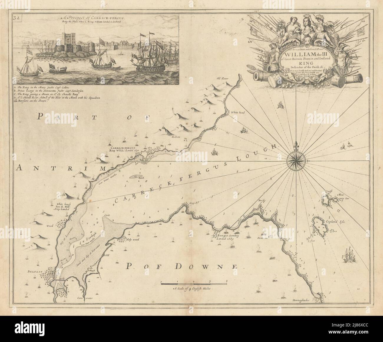
BELFAST LOUGH sea chart. 1690 William III at Carrickfergus. COLLINS 1723 map
Image details
Contributor:
Antiqua Print Gallery / Alamy Stock PhotoImage ID:
2J86XCCFile size:
109.3 MB (6.5 MB Compressed download)Releases:
Model - no | Property - noDo I need a release?Dimensions:
6805 x 5616 px | 57.6 x 47.5 cm | 22.7 x 18.7 inches | 300dpiDate taken:
1723Location:
IrelandMore information:
This image could have imperfections as it’s either historical or reportage.
[Carrickfergus Lough]. Inset: A prospect of Carreck-Fergus, being the place where King William landed in Ireland - To the most Potent and Heroick Prince William the III of Great Britain, France and Ireland; King, Defender of the Faith &c. This is most humbly dedicated and presented by Your Majes. Most dutifull and Loyall subject and servant Capt. G. Collins. Artist/engraver/cartographer: Captain Greenvile (or Greenville) Collins. Collins was an officer of the Royal Navy and prominent hydrographer, who was commissioned by King Charles II in 1676 and appointed by Samuel Pepys (then Secretary to the Admiralty), to chart the coasts of Great Britain. The resulting atlas - Great Britain's Coasting Pilot - was the first original sea atlas to be produced by an Englishman. Prior to publication of these maps, nautical charts were often defective, and there was no centralised system for collecting and disseminating the better maps made by experienced seamen. In 1681, Collins gained the king's preferment to survey the country's coasts. The Admiralty supplied Collins with the 8-gun yacht HMS Merlin for the first two years and later the yacht HMS Monmouth until 1686. His work was carried out under the supervision of Trinity House, who also supported the project financially. Samuel Pepys insisted that Collins be made a younger brother of Trinity House. Collins spent seven years on the survey, the first edition of which was published in 1693, as "Great Britain's Coasting Pilot". The charts, while not completely accurate, were an enormous advance on anything before them, entitling Collins to rank as not only one of the earliest, but also among the best of English hydrographers. Twenty-one further editions were published during the eighteenth century. Provenance: "Great Britain's Coasting Pilot: being a new and exact survey of the sea-coast of England and Scotland from the river of Thames to the westward and northward; with the islands of Scilly and from thence to Carlisle; likewise