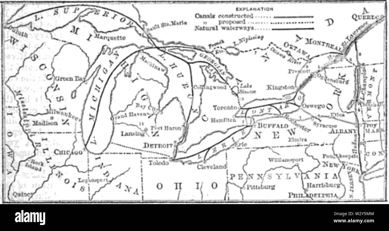
A map from the 1881 volume of Harper's Magazine shows the various canal projects on the Great Lakes. The dark black lines on the Lakes show major shipping routes already in use at that time. The Erie Canal can be seen running eastward from Buffalo to Troy. The Wood Creek navigation can be seen running from the eastern end of Lake Ontario as Oswego to meet the Erie. The Rideau Canal from Ottawa to the St. Lawrence can be seen running through Prescott. The proposed Michigan and Erie Canal can be seen in the lower left, running from the eastern side of Lake Michigan to Toledo on the Erie. This ro
Image details
Contributor:
Alpha Stock / Alamy Stock PhotoImage ID:
W2Y5MMFile size:
71.5 MB (1.2 MB Compressed download)Releases:
Model - no | Property - noDo I need a release?Dimensions:
6896 x 3624 px | 58.4 x 30.7 cm | 23 x 12.1 inches | 300dpiMore information:
This image is a public domain image, which means either that copyright has expired in the image or the copyright holder has waived their copyright. Alamy charges you a fee for access to the high resolution copy of the image.
This image could have imperfections as it’s either historical or reportage.
A map from the 1881 volume of Harper's Magazine shows the various canal projects on the Great Lakes. The dark black lines on the Lakes show major shipping routes already in use at that time. The Erie Canal can be seen running eastward from Buffalo to Troy. The Wood Creek navigation can be seen running from the eastern end of Lake Ontario as Oswego to meet the Erie. The Rideau Canal from Ottawa to the St. Lawrence can be seen running through Prescott. The proposed Michigan and Erie Canal can be seen in the lower left, running from the eastern side of Lake Michigan to Toledo on the Erie. This route competed with the Clinton–Kalamazoo Canal to Lake St. Clair, which is somewhat to the north , labeled 11. Neither was completed, although short sections of the Clinton–Kalamazoo were built. The relatively short Toronto and Georgian Bay Ship Canal can be seen running southeast off the southern tip of Georgian Bay, through Lake Simcoe and to Toronto. It was never built, although a short section of the route was used as the Holland River Division, abandoned when about 85%%%%%%%%%%%%%%%%%%%%%%%%%%%%%%%%%%%%%%%%%%%%%%%%%%%%%%%%%%%%%%%% complete. The longer Georgian Bay Ship Canal can be seen running from the northern side of Georgian Bay to Lake Nipissing, and then through the rivers to Ottawa and Montreal. This was heavily opposed by Toronto area businessmen, but remained on the books until 1927 when the company's charter ultimately lapsed. The proposed Caughnawaga Canal can be seen near the upper right edge of the image, connecting the Ottawa River just upstream from Montreal to Lake Champlain, and then joining the Erie Canal at Troy. This route would have made excellent sense if the Georgian Bay Ship Canal had been completed, as it exited at the northern end of the Caughnawaga. This route was also abandoned. Small numbers on the map label each route, but are difficult to see given the low resolution. They appear to be: 1) Erie Canal 2) Welland Canal 3) Locks around rapids