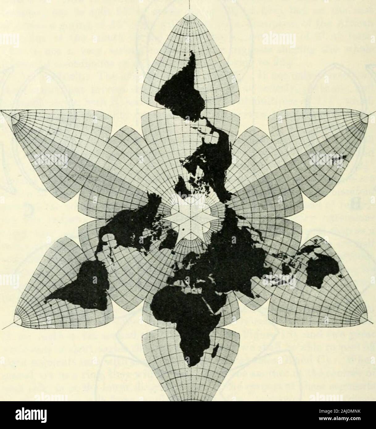
Scottish geographical magazine . Fig. 1-3.—Experiment with an orange. isolated and arbitrary, l)ut of very moderate error both of area andshape. By dividing each quadrant of 90° into four parts at intervals of 22|°,which harmonically coincide not only with the axes and boundaries ofeach section but with the zones of temperature, the type of projection 468 SCOTTISH GEOGRAPHICAL MACiAZlNE. and the quartering of each quadrant of latitude and longitude are the samefrom the zero of Greenwich to the zero of the Equator respectively—an arrangement which seems irresistibly logical and convincing. If e
Image details
Contributor:
The Reading Room / Alamy Stock PhotoImage ID:
2AJDMNKFile size:
7.1 MB (309.8 KB Compressed download)Releases:
Model - no | Property - noDo I need a release?Dimensions:
1530 x 1632 px | 25.9 x 27.6 cm | 10.2 x 10.9 inches | 150dpiMore information:
This image is a public domain image, which means either that copyright has expired in the image or the copyright holder has waived their copyright. Alamy charges you a fee for access to the high resolution copy of the image.
This image could have imperfections as it’s either historical or reportage.
Scottish geographical magazine . Fig. 1-3.—Experiment with an orange. isolated and arbitrary, l)ut of very moderate error both of area andshape. By dividing each quadrant of 90° into four parts at intervals of 22|°, which harmonically coincide not only with the axes and boundaries ofeach section but with the zones of temperature, the type of projection 468 SCOTTISH GEOGRAPHICAL MACiAZlNE. and the quartering of each quadrant of latitude and longitude are the samefrom the zero of Greenwich to the zero of the Equator respectively—an arrangement which seems irresistibly logical and convincing. If eachgroup of 22h be divided into three, we have co-ordinates every 7h°, which include the 15°, 30 , 45° . . series shown on most globes. Ifa 5, 10, 15, 20 . . series be preferred, then the axial and boundary. Fig. 14.—The completed map. For e.xplauatiou see te.l. meridians (2i plus) will lio omitted, and the ocean edge where goredwill show as a mere edge of colour. These are details for professional map-makers. So also are the niceaccommodations in plotting co-ordinates so as to equalise errors in manysubtle ways of too complicated a nature to be gone into thorotighlyhere. It might be pointed out that a map made on the projection of AN ACCOUNT OF A NEW LAND MAP OF THE WORLD. 469 Figures 11, 12 and 14, or with any of the variations to suit any of thenations of the earth, carefully printed on both sides with silk or cottonstiffening and hinge, and cut clean to the margins, could be made to foldin a leather case. By turning over the outermost sections, the SouthPolar regions could be brought into the same continuous relation that theNorth Polar regions have in Figure 11. A double map could be physicalon the obverse and political on the reverse, or bilingual, etc., etc. In conclusion, I wil