RMREDT1D–. Compendium of meteorology. Meteorology. RADAR STORM OBSERVATION 1277 pected that descriptions of radar detection of such phe- nomena as tornadoes, waterspouts, dust storms, and other atmospheric anomalies will be available. Forest fires sometimes appear as areas similar to weak rain- echo signals on PPI scopes. The lack of vertical develop- ment, coupled with other meteorological information, is usually sufficient to provide correct identification. It is unknown at present whether the temperature grad- ients or the cinders and ash carried aloft by convective currents cause the echoes. The sm

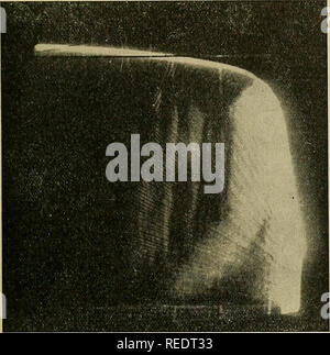
RMREDT33–. Compendium of meteorology. Meteorology. RADAR STORM OBSERVATION 1273 ditions as shown by an RHI scope. This spectacular phenomenon is best detected when the pi-ecipitation is due to convective causes as was the case when the photograph shown in Fig. 8 was obtained. Where the quires narrow beam width radars (less than 2°) and careful adjustment of antenna elevation angle and gain. Also, rather short pulse lengths must be employed for best presentation. It is interesting to note that perfectly. Fig. 8.—Photograph of RHI scope showing tall (snow) shower with abrupt shear below the altitude of 9
![. Compendium of meteorology. Meteorology. RADAR STORM OBSERVATION 1275 features in this type of precipitation except that, on occasion, it can be fairly uniform. Because of this factor, this type of precipitation might be useful for relating storm echo signals to precipitation intensity. C. Hurricanes and Typhoons. Radar detection of hur- ricanes and typhoons is even more dramatic than radar detection of cold-front squall lines [66]. The rain-distri- bution pattern as seen on a PPI scope is illustrated in Fig. 12. It is startling in its similarity to the symbol §. Fig. 12.âHurricane of 18-21 Stock Photo . Compendium of meteorology. Meteorology. RADAR STORM OBSERVATION 1275 features in this type of precipitation except that, on occasion, it can be fairly uniform. Because of this factor, this type of precipitation might be useful for relating storm echo signals to precipitation intensity. C. Hurricanes and Typhoons. Radar detection of hur- ricanes and typhoons is even more dramatic than radar detection of cold-front squall lines [66]. The rain-distri- bution pattern as seen on a PPI scope is illustrated in Fig. 12. It is startling in its similarity to the symbol §. Fig. 12.âHurricane of 18-21 Stock Photo](https://l450v.alamy.com/450v/redt20/compendium-of-meteorology-meteorology-radar-storm-observation-1275-features-in-this-type-of-precipitation-except-that-on-occasion-it-can-be-fairly-uniform-because-of-this-factor-this-type-of-precipitation-might-be-useful-for-relating-storm-echo-signals-to-precipitation-intensity-c-hurricanes-and-typhoons-radar-detection-of-hur-ricanes-and-typhoons-is-even-more-dramatic-than-radar-detection-of-cold-front-squall-lines-66-the-rain-distri-bution-pattern-as-seen-on-a-ppi-scope-is-illustrated-in-fig-12-it-is-startling-in-its-similarity-to-the-symbol-fig-12hurricane-of-18-21-redt20.jpg)
RMREDT20–. Compendium of meteorology. Meteorology. RADAR STORM OBSERVATION 1275 features in this type of precipitation except that, on occasion, it can be fairly uniform. Because of this factor, this type of precipitation might be useful for relating storm echo signals to precipitation intensity. C. Hurricanes and Typhoons. Radar detection of hur- ricanes and typhoons is even more dramatic than radar detection of cold-front squall lines [66]. The rain-distri- bution pattern as seen on a PPI scope is illustrated in Fig. 12. It is startling in its similarity to the symbol §. Fig. 12.âHurricane of 18-21

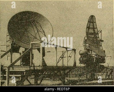
RMREDT6P–. Compendium of meteorology. Meteorology. RADAR STORM OBSERVATION 1267 where / is a dimensionless factor which depends on the design and efficiency of the antenna and parabola (usually about 0.6 or 0.7).. Fig. 1.—Antenna parabolas of two of the radars used by the M.I.T. Weather Radar Research. The parabolic reflector to the left forms a conical beam of circular cross section. The one to the right (AN/TPS-lOA) forms a "beaver-tail" beam of elliptical cross section 0.7° vertical and 2° horizontal. Both radars have an operating wave length of about 3 cm. (M.I.T. Weather Radar Research.)

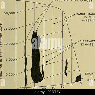
RMREDT3Y–. Compendium of meteorology. Meteorology. RADAR STORM OBSERVATION 1271 or other indicator operating in synchronism with the antenna azimuth control. This is also true for A- and R-scope azimuth readings. during the past few years and need little explanation, especially when accompanied by a synoptic map show- ing position and orientation of the surface front in the PRECIPITATION ECHOES 30,000 - RANGE MARKS AT 10 MILE NTERVALS. LOCATION / 0^ RADAR 5,000 60 50 40 30 RANGE (MILES) Fig. 5.—Diagram illustrating features of RHI scope of AJ^/TPS-lOA radar (X-band). Photographic images (and this diagr